
← Back to Directory
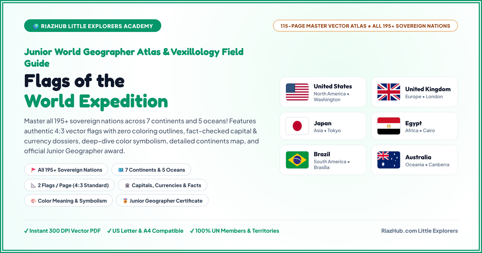
flags of the world featured image


🌍 Ages 5–14+ • Elementary & Middle Grade


📖 Complete 115-Page Master Atlas • 2 Flags Per Page


⚡ 300 DPI High-Res Vector PDF • Instant Download


🌐 All 195+ Sovereign Nations • Authentic 4:3 FlagCDN Vectors

★ RiazHub Little Explorers Academy • World Geography & Vexillology Series ★

Flags of the World & Continents Explorer — Junior World Geographer Atlas: 115 Deluxe Pages, All 195+ Sovereign Nations Across 7 Continents, 2 Flags Per Page in Authentic 4:3 Display, Detailed Continents & Oceans Map & Junior Geographer Certificate

Transform screen time into an exhilarating global vexillological expedition! A complete, museum-grade geography curriculum guiding young explorers through all 195+ sovereign nations across 7 continents and 5 oceans. Featuring exactly 2 flags per page framed in standard 4:3 aspect ratio display with authentic official FlagCDN vectors, complete educational dossiers (capitals, languages, currencies, landmarks, color meanings), spacious explorer passport credentials, and a prestigious completion award!

⚡
Instant Delivery
300 DPI Vector PDF directly to your device
🌍
All 195+ Nations
100% UN members & sovereign territories
📐
4:3 Flag Displays
2 flags per page with rich symbolism dossiers
🎖️
Junior Geographer
Official completion award with golden seal

GEOGRAPHIC RIGOR & GLOBAL CITIZENSHIP

The 4-Pillar Junior World Geographer Framework

Engineered specifically for homeschooling families, elementary & middle school geography units, and curious young minds:

🗺️

1. Continental Cartography

Kids master the 7 Continents and 5 Oceans, understanding regional boundaries, land areas, populations, and natural landmarks that shape each continent.

🚩

2. Vexillological Science

Discover flag anatomy (canton, field, hoist, fly), tricolors, Nordic crosses, saltires, and color symbolism that reveal centuries of national struggle and triumph.

🏛️

3. Geopolitical Literacy

Every sovereign nation pairs capital cities, official languages, currencies, and populations—building robust mental models of world geography and international affairs.

🤝

4. Global Citizenship

Fostering respect, cultural stewardship, and curiosity for diverse global neighbors from the Andes of Peru to the atolls of the South Pacific.

MUSEUM-GRADE VISUAL DESIGN

Peek Inside the 115 Master Spreads

Every page is engineered for visual elegance, featuring authentic FlagCDN vector flags inside official 4:3 aspect ratio containers with zero student coloring outlines:
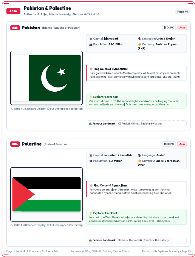
flags of the world featured image Screenshot

Pages 1 & 2
Passport Spread

🛂 Junior Explorer Passport Card

Spacious, full-width handwriting lines for Explorer’s Name, Age/Grade, Expedition Base City/Country, and Date, plus portrait frame and 7 continental visa stamp circles.

Official Passport Credentials & Global Oath

Inspires ownership and commitment before embarking across the 7 continents.

Page 4
World Cartography

🗺️ Detailed Continents & Oceans Map

Color-coded continental shapes, labeled 5 great oceans (Pacific, Atlantic, Indian, Arctic, Southern), equator and tropics lines, plus continental land area & population table.

Authentic Earth Cartography Projection

Crystal-clear vector rendering with zero broken links or blurriness.

Pages 5–111
Flag Spreads

📐 Exactly 2 Flags Per Page (4:3 Ratio)

No student coloring outlines! Each country features an authentic 4:3 vector flag from FlagCDN, capital, language, population, currency, landmark, and color symbolism.

All 195+ Sovereign Nations

From Algeria & Angola to Vanuatu & Zimbabwe, every nation is celebrated.

Page 115
Graduation Award

🎖️ Official Completion Award

Deluxe golden ribbon seal, young explorer name line, instructor signature, and honors citation celebrating geographic mastery across all 7 continents.

Junior World Geographer Certificate

A memorable, frame-worthy milestone for homeschooling portfolios.

COMPREHENSIVE CHAPTER-BY-CHAPTER DIRECTORY

Complete 115-Page Master Atlas Breakdown

Every sovereign country is sequenced logically by continent, displaying exactly 2 authentic 4:3 flags per spread:

Chapter / Spread Page Range Countries / Content Layout Standard
Front Matter & Passport Pages 1–4 Cover, Passport Credentials, Vexillology 101, 7 Continents Map Passport & Map
Continent 1: Africa Pages 5–32 Gateway + 54 Sovereign Nations (Algeria to Zimbabwe) 2 Flags / Page • 4:3
Continent 2: Asia Pages 33–57 Gateway + 48 Sovereign Nations (Afghanistan to Yemen) 2 Flags / Page • 4:3
Continent 3: Europe Pages 58–80 Gateway + 44 Sovereign Nations (Albania to Vatican City) 2 Flags / Page • 4:3
Continent 4: North America Pages 81–93 Gateway + 23 Nations (Antigua to USA) + Continental Review 2 Flags / Page • 4:3
Continent 5: South America Pages 94–100 Gateway + 12 Sovereign Nations (Argentina to Venezuela) 2 Flags / Page • 4:3
Continent 6: Oceania Pages 101–108 Gateway + 14 Sovereign Nations (Australia to Vanuatu) 2 Flags / Page • 4:3
Continent 7: Antarctica & Oceans Pages 109–112 Gateway + Antarctica True South & 5 Oceans 2 Flags / Page • 4:3
Capstone Activities & Certificate Pages 113–116 Vexillology Quiz, Flag Studio, Official Certificate, Back Cover Capstone Honors

AFFORDABLE HOMESCHOOL & CLASSROOM PRICING

Choose Your License & Start Today

Instant digital delivery to any device worldwide. Download once, print as many times as you need for your family or classroom:


🏠 IMMEDIATE FAMILY USE

Instant PDF

Standard Home Edition

Ideal for homeschoolers, geography-loving families, and curious explorers ages 5–14+.

$9.99
$19.99
SAVE 50%
  • ✔
    Complete 115-Page Master PDF (300 DPI High-Res Vector Edition)
  • ✔
    All 195+ Sovereign Nations across 7 Continents & 5 Oceans
  • ✔
    2 Flags Per Page in Official 4:3 Standard Display
  • ✔
    Junior World Explorer Passport & 7 Continental Visa Stamps
  • ✔
    High-Res Vector Continents & Oceans Map with statistical key
  • ✔
    Official Junior World Geographer Certificate with Gold Ribbon Seal
  • ✔
    Lifetime Personal Print Rights for all children in your household

📥 Download Standard Edition — $9.99

Instant Vector PDF Download • Lifetime Access

MOST POPULAR FOR EDUCATORS

🏫 CLASSROOM & SCHOOL LICENSE

Commercial Rights

Classroom & School Pack

Designed for geography teachers, co-ops, school libraries, and learning centers needing print copies for all students.

$14.99
$29.99
SAVE 50%
  • ✔
    Everything in Standard Home Edition included
  • ✔
    Commercial & Institutional License for up to 50 students per year
  • ✔
    Unlimited Classroom, Library & Co-op physical print reproductions
  • ✔
    Perpetual Multi-Student Rights: Re-use semester after semester
  • ✔
    Bulk Certificate Printing: Print unlimited graduation awards
  • ✔
    Priority Support & Updates whenever UN recognitions change

📥 Download Classroom License — $14.99

Instant Delivery • Classroom Rights Certificate Included

🖨️ Home Printing, Paper & Binding Guide

How to get vibrant, durable, museum-grade results from your home printer:

📄

Recommended Paper:

Use 24 lb or 28 lb bright white paper for crisp, non-bleed flag prints. For the cover and certificate, 65 lb cardstock gives a luxurious feel!

⚙️

Printer Settings:

Set scaling to “Fit to Printable Area” or 100% Actual Size. Choose “High Quality” or “Photo Paper” mode for rich color saturation.

📚

Binding Options:

Spiral binding at your local office store ($3–$5) lets the atlas lay completely flat. Alternatively, use a 3-ring binder with sheet protectors!

COMMON QUESTIONS & ANSWERS

Frequently Asked Questions

Are all 195+ world sovereign nations included in this atlas?
▼
Yes, 100%! The atlas covers all 193 United Nations Member States, both permanent UN observer states (Vatican City and State of Palestine), widely recognized sovereign territories (Kosovo, Taiwan), as well as Antarctica (True South) and Earth’s 5 major oceans. Exactly 2 nations are presented per page in clean 4:3 standard framing!
Why does this edition feature 2 flags per page in a 4:3 area with no coloring outlines?
▼
Based on feedback from educators and parents, this edition is designed as a pristine, high-fidelity Reference & Geography Discovery Atlas. Removing coloring outlines allows flags to be presented in their exact official colors, crisp vector geometry, and standard 4:3 proportions, leaving maximum space for comprehensive dossiers including capital cities, languages, populations, currencies, landmarks, and flag symbolism.
What ages is this geography atlas designed for?
▼
The atlas is ideal for ages 5 to 14+ (Kindergarten through 8th Grade). Younger children love identifying colors, symbols, animals, and sun/moon emblems on flags, while elementary and middle-schoolers dive deep into capitals, continental stats, currencies, languages, and geopolitical literacy.
What digital format do I receive upon purchasing?
▼
You will receive an instant download link for the high-resolution 300 DPI vector PDF formatted in standard US Letter size (8.5 × 11 inches), which prints flawlessly on standard A4 paper worldwide. You can save it to any computer, tablet, iPad, or mobile phone and print as many times as you like.
Where are the official flag images sourced from?
▼
All flag artwork is linked from authoritative ISO 3166-1 alpha-2 vector repositories (FlagCDN), ensuring official proportions, accurate crests, proper color hex codes, and authentic national heraldry with zero cropping.

Ready to Explore All 195+ Flags of Planet Earth?

Give your young geographer the ultimate reference atlas. Instant 300 DPI vector PDF download with lifetime print rights.


⚡ Download the 115-Page Master Atlas Now ($9.99)

★ Verified Tool Feedback

User Reviews & Ratings

Authentic feedback and star ratings from real users of this tool. All reviews are approved by our administrator.

5.0
Default 5.0 Star Rating (0 Reviews)
🛡️ Verified & Moderated
5 ★
0
4 ★
0
3 ★
0
2 ★
0
1 ★
0

💬 Community Feedback (0)

⭐

No Reviews Yet

This tool currently has our default 5.0 ★ rating. Have you used this tool? Be the first to share your experience below!

✍️ Add Your Feedback

Leave a Review for This Tool

Rate your experience. Reviews are approved by our administrator before appearing on the site.

5.0 ★ Excellent
✨ CUSTOM ON-DEMAND CREATIONS

Have a Custom Demand? We Build Tools, Website Templates, PDF Books & Crochet Patterns and much more

Need a custom web tool, specialized website theme or template, educational children's PDF book, bespoke crochet pattern design, or personalized digital utility? Founder MUHAMMAD RIAZ Khan Jee and the RiazHub team work directly to customer demand. Contact us with your project details and get tailored solutions delivered promptly.

⚡ Custom Web Tools 🎨 Website Templates & Themes 📚 Children's Printable PDF Books 🧶 Crochet Design Patterns 🛠️ Custom PDF & Digital Files
🌐 Visitor Statistics
784
Today
16,182
This Month
34,294
Previous Month
86,962
Total Visits